A Brief History of the River Foss
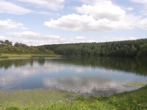
The River Foss has seen many changes over the years, especially in its lower reaches around the city of York. It’s source, near Newburgh Priory in what was the forest of Galtres, is a spring adjacent to Oulston Reservoir (sometimes called Pond Head Reservoir), into which it then flows. According to Fife and Walls* it drains some 30,000 acres of flat farmland and takes 23¾ miles to reach its confluence with the Ouse, only 14½ miles away as the crow flies. This gives some idea of just how winding its course is. The Foss drops 300 feet during its passage, most of which happens during the first few miles, with water taking about 48 hours, under normal conditions, to get from Oulston Reservoir, to Blue Bridge where it meets the Ouse in York.
 Above Sheriff Hutton it is primarily a drain for the surrounding land and as such has been modified continually to better remove water from the fields, and to reduce flooding. From Oulston to Crayke, it still looks fairly natural, but below there it has suffered the ravages of years of straightening and moving to suit landowners. Still further down, below Sheriff Hutton, and even more so below Strensall, it has been highly modified and was canalised in the 18th century.
The Foss was dammed at York in the 11th century creating a lake which was part of the city defences, hence the lack of a wall between Red Tower and Monk Bar. It’s nigh-on impossible to attack a city across a swamp! The lowest reaches of the Foss, from the city of York to the confluence with the Ouse was tidal until the building of Naburn Lock on the Ouse below York in 1757.
Sedimentation is, and always has been, a major problem along the Foss; not surprising given its primary function as a means for draining farmland. Consequently, the lake gradually became a swamp in which a number of islands developed (hence Foss Islands) by Layerthorpe bridge, then a major access route to the city, and it ceased to be a useful defence. It was called “The King’s Fishpool”, which in itself indicates its primary use for some years.
As the city grew and produced ever more waste, and as the Foss filled itself in and its flow almost ceased, the smell became unbearable, and the consequences for residents’ health became a concern, even in those times. It reached the stage where water coming down the river found it difficult to get to the Ouse at all. However, then, as now, it took a while to get everyone involved organised and in agreement. In 1736, the well-respected York surgeon, Francis Drake, produced his ‘Eboracum’, or ‘The History and Antiquities of the City of York’, the first and most influential history of the city. He suggested that the Foss, if properly drained and cleaned, could be useful for transporting lime and coal into the rural catchment area north of York, and for bringing agricultural produce out.
For all the miasma and its general state of disrepair, the Foss was still an important part of York’s waterfront with the first ever recorded launch of an iron boat, “The York Courant”, happening in 1777. It was a pleasure craft some 12 feet long, supposedly capable of carrying 15 persons!
Not until 1791 though, did the local landowners get together and decide to undertake the necessary drainage work and then to build a canal as far as Sheriff Hutton. They formed the Foss Navigation Company with initial capital of £25,000 to undertake the work. This was later raised to £35,000 to cover shortfalls and overspending (familiar?). The work, which started in 1793, was hampered by incompetent supervision and poor workmanship, to the extent that it ran out of money before reaching Sheriff Hutton. It was opened as far as Strensall by 1797 and had struggled almost to its intended terminus by 1802 when work stopped.
To give some idea of the advantages of canal haulage in a time when there were few usable roads, and those that there were quickly became a morass in rainy weather, the following comparisons are interesting. A horse could pull – 1 ton on a good level road – 3 tons in a wagon on rails or 27 tons in a boat on a still canal. Having said which, due to the towpaths available and the difficulty of getting a horse across the river when it changed sides, haulage along the Foss mainly used manpower, except in its lower reaches.
Six locks were built to allow the canal to gain the necessary height as the land rose, and a new cut was built above Strensall where the river course was too tortuous to follow. Also, in 1796, Oulston Reservoir was built just below the source to provide sufficient water to allow the locks to operate. Despite a pumping system being installed at Castle Mills Lock to pump back water used in operating the lock, low summer flows were always a problem, and there was rarely enough water to guarantee passage all year every year, which added to the canal’s problems, and pushed users to find alternative routes and to improve roads.
The locks were:
- Castle Mills
- Yearsley
- Steel’s Lock (New Earswick just downstream of the N E Railway Bridge, now Link Road)
- Haxby/Earswick
- Strensall Lower Lock (just upstream of “Old Humpy” Bridge)
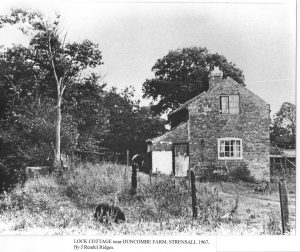
- Strensall Upper Lock (Duncombe Farm – a double lock)
 Most were provided with a lock keeper’s cottage – as much as anything else, to prevent unauthorised release of water through the locks, something which dogged the undertaking for many years. Most of these are in private hands and are still occupied.
Hundreds of thousands of bricks were used in its construction, for bridges, culverts and locks as well as the odd building, with pretty much all of them being made locally – transport was not practical over any distance. Brickworks were recorded in Yearsley, Huby, Sheriff Hutton, Flaxton, Strensall, Haxby, and Huntington, each with its own excavation for clay, many of which are still visible today as ponds.
The navigation was never a financial success. It brought in coal, much of it for domestic use, and lime for spreading on the fields, as well as bones to the works at Stillington where they were ground and also used on the fields as meal. It is even suggested that human bones from the battlefields of Europe (Austerlitz, Waterloo etc) may have ended up there! One of the Company’s problems was that it was not allowed to be a common carrier and so had to rely upon dues and fees – never an easy negotiation.
The canal carried manure downstream, and corn and some dairy products, though in much smaller quantities were taken upstream. In 1793 for instance, around 3400 tons were carried upstream, more than 90% being lime, with only 50 tons taken downstream. By 1801 some 6400 tons were being carried upstream compared to less than 3000 tons being taken downstream. Dividends were small and sporadic, particularly after 1805, and ceased altogether in the 1840s.
The area served by the Navigation Company was rural with a population rising slowly from around 6000 in 1800 to just over 9000 in 1850, and the arrival of the canal changed the mix of local trades quite considerably, both by offering direct employment on the Navigation, and by allowing raw materials and larger items of equipment to be brought in for local use, so that local manufacture was possible rather than everything having to be transported in.
The largest barges were up to 55 feet long and 14 feet wide, with a draught of 4 feet, carrying as much as 50 tons each. Though how far up-river such large barges could go is another matter. Sedimentation continued to be a major problem with much effort needed to dredge the canal and keep traffic flowing. To this was added the need to maintain the roads which allowed goods carried by barge to the various landings to be transported from or delivered to their consignees. This was usually the responsibility of the parish councils, but again, was a constant battle, with funding never easy.
Things staggered on into the 1840s when the arrival of three railways finished off what the gradual improvement of the roads had started. Sedimentation, ever reducing usage, and general maintenance arrears reduced access to the upper navigable reaches and the arrival of the Scarborough Railway at Haxby and Strensall in 1849 and the Hull Railway in Huntington in 1847 led to the abandonment of the canal, initially above Strensall, then in 1859 above Yearsley bridge. The Foss Navigation was but the first of many canals to succumb to railway competition. Finally, in 1879 a goods station was built by the North Eastern Railway on reclaimed land roughly opposite where Go Outdoors now trades.
 It was hardly surprising, given the lack of river traffic, poor flow and flourishing weeds in summer, that all the old problems associated with sedimentation returned with a vengeance. Greatly increased levels of waste from the city of York, both industrial and human meant that yet again, the Foss had become a long smelly, infested, muddy problem, and as was usual in the 19th century, many of the city’s sewers drained into it. All of which led to York City Council being forced to buy out the Foss Navigation Company in 1853. Over the next few years some 20 miles of drains were laid, Osbaldwick and Tang Hall Becks were diverted and became pumped, and the main course of the Foss was dredged to get it moving again. The locks had been by-passed by 1894 to improve the flow, with the river often being returned to its original course, though they were not generally removed until some years later, and the canal cut that had been dug above Strensall was filled in.
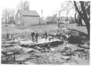
The remains of most of the locks can still be found, if you know where to look. For more information on those around Strensall, see the article below “Foss Navigation at Strensall” by John Millett
 Lock Chamber, Duncombe Farm, Strensall
.
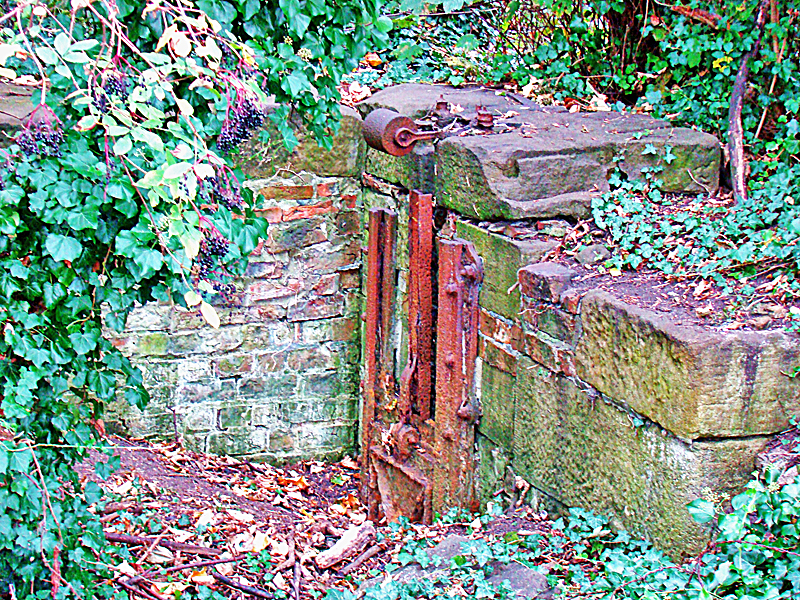
Rusting equipment on the old lock chamber just outside New Earswick
In 1859 the bottom of the river just by Yearsley bridge was paved and used as a free swimming pool, only falling out of use in the 1930s. The principal founder of the RFS, the late Bill Sessions, could remember swimming there.
The perennial problem of flow was always present, particularly in summer. It was not helped by the many businesses which used the river water in one way or another. There were mills at Crayke, Stillington, Marton Abbey, Marton cum Moxby, all of which all of which used energy which otherwise would have helped the flow in the river. Strensall Tannery abstracted water, as did the army camp at Strensall (1.4m gallons a year). On top of that, sewage treatment plants at Stillington and Walbutt’s upstream from Strensall did little to help water quality, by adding in a significant load of nitrogen, and until fairly recently, phosphate too.
 The lower reaches of the river were still busy at the start of the 20th century. Leetham’s flour mill, several coal yards, The York Press and Redfearn’s National Glass were among the users of the river. The gradual increase in road transport after the First Word War saw waterway use decline, not just on the Foss, but throughout the UK. Leetham’s continued to use the river until sold to Spillers, then later in 1931 a massive fire destroyed much of their grain mill. The remaining building, on the opposite bank, was bought by Rowntrees in 1937 and was used to receive and store sugar and gum, and later chocolate crumb, up until the 1970s. It is now an office and residential block.
By the end of the 70s there were only two users. Walker’s sand and coal merchants used what is now Travis Perkins yard, emptying their dredger “Reklaw” by grab-crane over a sheltered passage for riverside pedestrians, which was only demolished in 2019, and The York Press bringing paper up to Wormald’s Cut for their printing works until 1997. Since then the only remaining lock, at Castle Mills, has seen less and less use. It is still possible to use the lock, which is the responsibility of CYC but can be operated by trained Inland Waterways Association and RFS volunteers through a “Memorandum of Understanding” between CYC and IWA.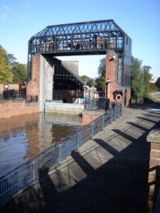
Perhaps the biggest change to the river in recent years was the construction of the Foss Barrier, which opened in November 1988, built to prevent the Ouse backing up into the Foss and causing flooding along its banks through the city and for some way above. Historically, this was reputed to have reached Haxby, and had been a significant problem since at least Roman times.
The normal water level of the Ouse at York is 5 metres above datum. When it reaches 7.8 metres the barrier is lowered into the Foss once any silt has been flushed out. The barrier weighs 16.5 tonnes and is operated as a turnover lift gate. When open it is held horizontally above the river so that boats can pass underneath. It takes only 4 minutes to lower it into position. Pumps maintain the water level of the Foss at around 1.5 metres above its normal level. Rebuilding to a higher specification following the Boxing Day 2015 floods is now nearly finished.
Mike Gray January 2020
* The brief history above was derived from several sources, primarily “The River Foss by Fife and Walls – Sessions 1981” and “Foss Navigation by Mitchell – Sessions 2000” as well as Wikipedia. The two booklets are out of print, but are well worth getting hold of for further reading.
The Foss Navigation at Strensall.
Situated six miles upstream from York, the industrial archaeology of the Foss Navigation Canal can be clearly seen in Strensall village. Evidence of the canal in the village includes a low level lock and the remains of a dry dock for the transfer of cargo. A second lock known as the double high rise lock together with the lock keeper’s house is situated further upstream
Strensall New Bridge, known locally as Old Humpy, dates from 1796 and is surprisingly one of the oldest bridges in York. It’s in regular use today, albeit with a traffic weight of 7.5 tonnes. The bridge is situated next to the low rise lock but all that remains of the lock are its walls, the lock gates having been removed. The lock walls are in order but crumbling in places. The River Foss Society has been involved in having some offending trees removed whose roots were damaging the lock walls.
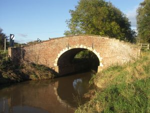
In the centre of the village crossing the River Foss is Strensall Bridge, built by John Carr in 1793. This bridge and “Old Humpy” are listed structures under Historic England records. In the centre of the village, close by Strensall Bridge, is the remains of a dock, known locally as the “dry dock”, which was thought to be used for the transfer of canal cargoes. The dock still has part of its sluice gate winding gear in place.
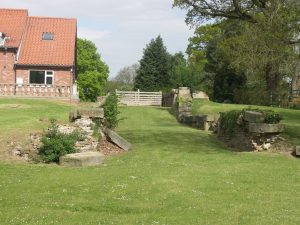
Situated approximately one mile upstream was the double high rise lock. This was installed at right angles to the river and was built to take a newly dug section of the canal over the high ground, north to Sheriff Hutton Bridge, a distance of some 1.6 miles, where the canal terminated. It was intended to install the canal as far as Stillington but the canal builder ran out of funds, so Sheriff Hutton Bridge became the canal terminus. Situated at Sheriff Hutton Bridge were a small hotel and a reservoir, last used in 1852, but nothing remains there now, the area together with the new canal having been back filled and returned to agriculture. However the route of the canal from the high rise lock can still be made out, in parts, by the rows of trees lining the route. The site of the high rise lock together with the lock keeper’s house has been transformed; the lock has been back filled and the lock keeper’s house has been converted into an attractive country property. The position of the lock can still be seen as the top of the lock wall is visible in the garden of the property as it slopes down to the river bank.
John Millett. April 2020
Acknowledgements. “The River Foss-Its History and Natural History” by Fife and Walls, “Foss Navigation” by Tessa Mitchell.
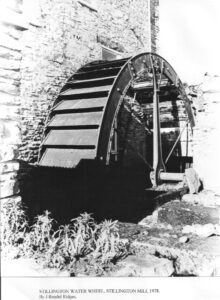
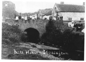
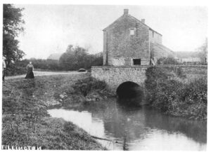
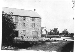
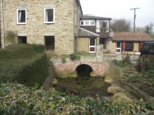
Stillington Mill.
Stillington Water Mill was one of several mills powered by the river Foss and it was first mentioned in the Domesday Book. The present building is approximately 350 years old. It was last used as flour mill in 1962, it is believed that Mr Geoffrey Shephard was the last miller, and when he left, the Mill was closed down and allowed to fall into disrepair. Since then the mill has been converted, first into a hotel,and then into a country house.
As it was…………….
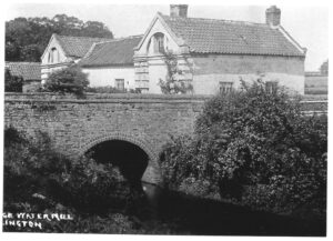
And more recently
Stillington Mill 21st C